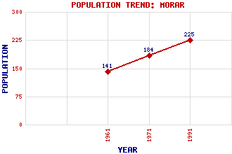
Morar Classification and Statistics Settlement Type: village Population (1991): 225 (1971): 184 (1961): 141 Tourist Rating: N/A Text of Entry Updated: 30-AUG-2017 Location Latitude: 56.9696°N Longitude: 5.8235°W National Grid Reference: NM 677 930 A range of modern and historical maps are accessible through the map tab on the right of this page Get directions by entering the UK postcode of your location, home or hotel here eg. EH1 3YT Use the tabs on the right of this page to see other parts of this entry Related Entries There are 16 related entries. (2 Attractions, 1 Council Area, 1 Historical County, 8 Features, 1 Parish, 1 Person and 2 Settlements) Names that are not linked do not currently contain any information. Attractions: Morar Sands West Highland Line Council Area: Highland Features: Aird nam Fiasgan, Camas Lochaber Morar Morar Bay Morar Railway Station Morar, Loch Morar, River Rhubana Lodge Historical Counties: Inverness-shire Parishes: Glenelg People: Lieut-Colonel Sir (Archibald) David Stirling Settlements: Lettermorar Mallaig
There are 16 related entries. (2 Attractions, 1 Council Area, 1 Historical County, 8 Features, 1 Parish, 1 Person and 2 Settlements)
Names that are not linked do not currently contain any information.
By using our site you agree to accept cookies, which help us serve you better