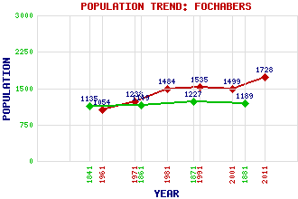
Fochabers Classification and Statistics Settlement Type: village Population (2011): 1728 (2001): 1499 (1991): 1535 (1981): 1484 (1971): 1238 (1961): 1054 (1881): 1189 (1871): 1227 (1861): 1149 (1841): 1135 Tourist Rating: Text of Entry Updated: 21-SEP-2015 Location Latitude: 57.6135°N Longitude: 3.0979°W National Grid Reference: NJ 345 587 A range of modern and historical maps are accessible through the map tab on the right of this page Get directions by entering the UK postcode of your location, home or hotel here eg. EH1 3YT Use the tabs on the right of this page to see other parts of this entry Related Entries There are 37 related entries. (7 Attractions, 1 Council Area, 1 Historical County, 2 Families, 10 Features, 1 Parish, 7 People and 8 Settlements) Names that are not linked do not currently contain any information. Attractions: Baxters Visitor Centre Fochabers Folk Museum, The Meikle Dramlach Bridge Speyside Way Tugnet Ice House Whiteash Cairn Women's Land Army Memorial Council Area: Moray Families: Baxter Gordon Features: Aberdeen-Inverness Line Garmouth and Kingston Golf Club Gordon Castle Milne's High School Spey Bay Golf Course and Driving Range Spey, River Speymouth Forest St Ninian's Chapel Whiteash Hill Whiteash Hill Wood Historical Counties: Moray Parishes: Bellie People: Audrey Baxter William Alexander Baxter James Boswell George Chalmers Dr. Samuel Johnson William Marshall Alexander Milne Settlements: Aberdeen Buckie Elgin Inverness Lhanbryde Mosstodloch Newton Orbliston
There are 37 related entries. (7 Attractions, 1 Council Area, 1 Historical County, 2 Families, 10 Features, 1 Parish, 7 People and 8 Settlements)
Names that are not linked do not currently contain any information.
By using our site you agree to accept cookies, which help us serve you better