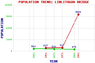
Linlithgow Bridge Classification and Statistics Settlement Type: suburb Population (1981): 9544 (Combined with Linlithgow) (1971): 917 (1961): 827 (1881): 479 (1871): 503 (1861): 560 Tourist Rating: N/A Text of Entry Updated: 28-FEB-2014 Location Latitude: 55.9776°N Longitude: 3.6254°W National Grid Reference: NS 986 772 A range of modern and historical maps are accessible through the map tab on the right of this page Get directions by entering the UK postcode of your location, home or hotel here eg. EH1 3YT Use the tabs on the right of this page to see other parts of this entry Related Entries There are 20 related entries. (3 Attractions, 1 Council Area, 1 Historical County, 10 Features, 1 Parish, 2 People and 2 Settlements) Names that are not linked do not currently contain any information. Attractions: Lennox Cairn Linlithgow Bridge Battlefield River Avon Heritage Trail Council Area: West Lothian Features: Avon Viaduct Carribber Castle Carribber Glen Edinburgh-Dunblane Line Kettleston Hills Linlithgow Bridge Longcroft House Mains Burn Mill Burn William Craigs Historical Counties: West Lothian Parishes: Linlithgow People: Sir James Hamilton of Finnart John Stewart(3rd (or 12th) Earl of Lennox) Settlements: Avontoun Linlithgow
There are 20 related entries. (3 Attractions, 1 Council Area, 1 Historical County, 10 Features, 1 Parish, 2 People and 2 Settlements)
Names that are not linked do not currently contain any information.
By using our site you agree to accept cookies, which help us serve you better