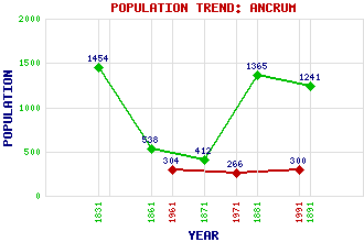
Ancrum Classification and Statistics Settlement Type: village Population (1991): 300 (1971): 266 (1961): 304 (1891): 1241(For parish) (1881): 1365(For parish) (1871): 412 (1861): 538 (1831): 1454(For parish) Tourist Rating: N/A Text of Entry Updated: 19-FEB-2002 Location Latitude: 55.5128°N Longitude: 2.5906°W National Grid Reference: NT 628 245 A range of modern and historical maps are accessible through the map tab on the right of this page Get directions by entering the UK postcode of your location, home or hotel here eg. EH1 3YT Use the tabs on the right of this page to see other parts of this entry Related Entries There are 17 related entries. (3 Attractions, 1 Council Area, 1 Historical County, 8 Features, 1 Parish, 1 Person and 2 Settlements) Names that are not linked do not currently contain any information. Attractions: Ancrum Moor Harestanes Visitor Centre Monteath Mausoleum Council Area: Scottish Borders Features: Ale Water Chesters Gersit Law Lilliards Edge Lilliardsedge Holiday Park Macedonia Teviot, River Teviotdale Historical Counties: Roxburghshire Parishes: Ancrum People: General Sir Thomas Monteath Douglas Settlements: Belses Jedburgh
There are 17 related entries. (3 Attractions, 1 Council Area, 1 Historical County, 8 Features, 1 Parish, 1 Person and 2 Settlements)
Names that are not linked do not currently contain any information.
By using our site you agree to accept cookies, which help us serve you better