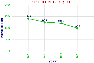
Nigg Classification and Statistics Settlement Type: village Population (1881): 1000 (1871): 1201 (1861): 1253 (1831): 1404 Tourist Rating: N/A Text of Entry Updated: 25-NOV-2007 Location Latitude: 57.7182°N Longitude: 4.0094°W National Grid Reference: NH 804 716 A range of modern and historical maps are accessible through the map tab on the right of this page Get directions by entering the UK postcode of your location, home or hotel here eg. EH1 3YT Use the tabs on the right of this page to see other parts of this entry Related Entries There are 22 related entries. (0 Attractions, 1 Council Area, 1 Historical County, 11 Features, 1 Parish, 1 Person and 7 Settlements) Names that are not linked do not currently contain any information. Council Area: Highland Features: Bayfield House Bayfield Loch Black Isle Cromarty Cromarty Firth Easter Ross Greg Ness Nigg Bay Nigg Station Nigg, Hill of Pitcalzean House Historical Counties: Ross and Cromarty Parishes: Nigg People: Eric Robert Linklater Settlements: Ankerville Corner Calrossie Castlecraig Cromarty Invergordon Nigg Ferry Pitcalnie
There are 22 related entries. (0 Attractions, 1 Council Area, 1 Historical County, 11 Features, 1 Parish, 1 Person and 7 Settlements)
Names that are not linked do not currently contain any information.
By using our site you agree to accept cookies, which help us serve you better