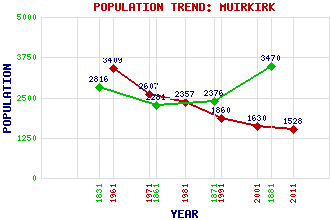
Muirkirk Classification and Statistics Settlement Type: village Population (2011): 1528 (2001): 1630 (1991): 1860 (1981): 2357 (1971): 2607 (1961): 3409 (1881): 3470 (1871): 2376 (1861): 2281 (1831): 2816 Tourist Rating: No Text of Entry Updated: 19-NOV-2007 Location Latitude: 55.521°N Longitude: 4.0685°W National Grid Reference: NS 695 272 A range of modern and historical maps are accessible through the map tab on the right of this page Get directions by entering the UK postcode of your location, home or hotel here eg. EH1 3YT Use the tabs on the right of this page to see other parts of this entry Related Entries There are 50 related entries. (3 Attractions, 1 Council Area, 1 Historical County, 1 Event, 28 Features, 1 Parish, 3 People and 12 Settlements) Names that are not linked do not currently contain any information. Attractions: Heritage Layby Kames Motorsport Complex MacAdam's Stone Council Area: East Ayrshire Events: Battle of Aird's Moss Features: Aird's Moss Bankend Rig Wind Farm Belt Knowe Brack Hill Cairn Table Dippal Rig Drummond's Knowe Dunside Rig Earl Hill Ettrick Cairn Glenbuck Loch Glengavel Reservoir Glenmuirshaw Goodbush Hill Grindstone Rig Hawlk Hill Inner Tod Hill Little Cairn Table Middlefield Law Millstone Rig Muirkirk Golf Club Muirkirk Uplands Ponesk Burn Priesthill Heights Scar Hill Stony Hill Threeshire Hill Wee Hill Historical Counties: Ayrshire Parishes: Muirkirk People: Thomas Edington John Loudon MacAdam(John Loudon McAdam) Jack Wilson McConnell(Lord McConnell of Glenscorrodale) Settlements: Cumnock Douglas Douglas West Dungavel Glenbuck Glenmuirshaw Kames Lugar Nether Wellwood Netherwood Smallburn Spireslack
There are 50 related entries. (3 Attractions, 1 Council Area, 1 Historical County, 1 Event, 28 Features, 1 Parish, 3 People and 12 Settlements)
Names that are not linked do not currently contain any information.
By using our site you agree to accept cookies, which help us serve you better