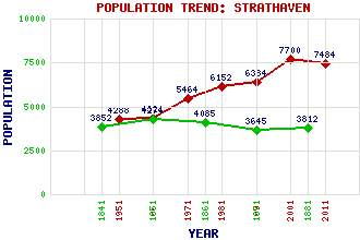
Strathaven Classification and Statistics Settlement Type: small town Population (2011): 7484 (2001): 7700 (1991): 6384 (1981): 6152 (1971): 5464 (1961): 4321 (1951): 4288 (1881): 3812 (1871): 3645 (1861): 4085 (1851): 4274 (1841): 3852 Tourist Rating: Text of Entry Updated: 11-DEC-2020 Location Latitude: 55.6774°N Longitude: 4.0657°W National Grid Reference: NS 702 446 A range of modern and historical maps are accessible through the map tab on the right of this page Get directions by entering the UK postcode of your location, home or hotel here eg. EH1 3YT Use the tabs on the right of this page to see other parts of this entry Related Entries There are 54 related entries. (6 Attractions, 1 Council Area, 1 Historical County, 22 Features, 1 Parish, 9 People and 14 Settlements) Names that are not linked do not currently contain any information. Attractions: Avendale Old Parish Church John Hastie Museum, The Strathaven Arts Centre Strathaven Castle Strathaven East Parish Church Strathaven Park Council Area: South Lanarkshire Features: Allison Green Auchingilloch Avon Water Avondale Calder Water Drumclog Battlefield Dungavel Castle Dungavel Hill Goodbush Hill Kype Reservoir Kype Water Laird's Seat Lauder Ha Lochar Water Logan Reservoir Powmillon Burn Strathaven Academy Strathaven Airfield Strathaven Cemetery Strathaven Golf Club Strathaven Public Hall West Browncastle Wind Farm Historical Counties: Lanarkshire Parishes: Avondale People: William Cochran William (Willie) Fernie John Hastie Louisa Jordan Sir Harry Lauder Thomas Leiper Robert Lochore Una McLean James 'Purlie' Wilson Settlements: Ardochrig Caldermill Chapelton Couplaw Drumclog Dungavel Eaglesham East Kilbride Flemington Glassford Hamilton Sandford Stonehouse Udstonhead
There are 54 related entries. (6 Attractions, 1 Council Area, 1 Historical County, 22 Features, 1 Parish, 9 People and 14 Settlements)
Names that are not linked do not currently contain any information.
By using our site you agree to accept cookies, which help us serve you better