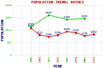
Rothes Classification and Statistics Settlement Type: village Population (2011): 1252 (2001): 1156 (1991): 1345 (1981): 1424 (1971): 1204 (1961): 1106 (1951): 1211 (1901): 1621(Police Burgh) (1881): 2201 (1871): 2148 (1861): 2407 (1831): 1709 Tourist Rating: Text of Entry Updated: 04-JUN-2006 Location Latitude: 57.5271°N Longitude: 3.2089°W National Grid Reference: NJ 277 492 A range of modern and historical maps are accessible through the map tab on the right of this page Get directions by entering the UK postcode of your location, home or hotel here eg. EH1 3YT Use the tabs on the right of this page to see other parts of this entry Related Entries There are 22 related entries. (2 Attractions, 1 Council Area, 1 Historical County, 2 Families, 13 Features, 1 Parish, 0 People and 2 Settlements) Names that are not linked do not currently contain any information. Attractions: Cardhu Distillery Glen Grant Distillery Council Area: Moray Families: Grant Leslie Features: Ben Aigan Brown Muir Brylach Hill Cairn Cattoch Elchies Forest Green Hill Hunt Hill Knock More Pikey Hill Rothes Golf Course Rothes Wind Farm Rothes, Burn of Rothes, Glen of Historical Counties: Moray Parishes: Rothes Settlements: Craigellachie Dandaleith
There are 22 related entries. (2 Attractions, 1 Council Area, 1 Historical County, 2 Families, 13 Features, 1 Parish, 0 People and 2 Settlements)
Names that are not linked do not currently contain any information.
By using our site you agree to accept cookies, which help us serve you better