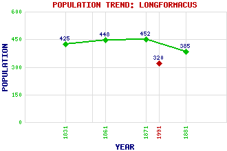
Longformacus Classification and Statistics Settlement Type: village Population (1991): 320 (1881): 385 (1871): 452 (1861): 448 (1831): 425 Tourist Rating: No Text of Entry Updated: 22-JUN-2006 Location Latitude: 55.8079°N Longitude: 2.4945°W National Grid Reference: NT 691 573 A range of modern and historical maps are accessible through the map tab on the right of this page Get directions by entering the UK postcode of your location, home or hotel here eg. EH1 3YT Use the tabs on the right of this page to see other parts of this entry Related Entries There are 28 related entries. (3 Attractions, 1 Council Area, 1 Historical County, 12 Features, 1 Parish, 2 People and 8 Settlements) Names that are not linked do not currently contain any information. Attractions: Longformacus House Sir Walter Scott Way Southern Upland Way Council Area: Scottish Borders Features: Black Hill Wind Farm Blacksmill Burn Cranshaws Hill Dye Water Ellemford Bridge Lammermuir Hills Lochend Mainslaughter Hill Penshiel Hill Watch Water Watch Water Reservoir Wrunk Law Historical Counties: Berwickshire Parishes: Longformacus People: William Adam James Smith Settlements: Cranshaws Duns Gavinton Polwarth Preston Primrosehill Westruther Whitchester
There are 28 related entries. (3 Attractions, 1 Council Area, 1 Historical County, 12 Features, 1 Parish, 2 People and 8 Settlements)
Names that are not linked do not currently contain any information.
By using our site you agree to accept cookies, which help us serve you better