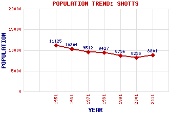
Shotts Classification and Statistics Settlement Type: small town Population (2011): 8801 (2001): 8235 (1991): 8756 (1981): 9427 (1971): 9512 (1961): 10304 (1951): 11125 Tourist Rating: No Text of Entry Updated: 04-JUN-2006 Location Latitude: 55.8217°N Longitude: 3.8083°W National Grid Reference: NS 868 602 A range of modern and historical maps are accessible through the map tab on the right of this page Get directions by entering the UK postcode of your location, home or hotel here eg. EH1 3YT Use the tabs on the right of this page to see other parts of this entry Related Entries There are 33 related entries. (2 Attractions, 1 Council Area, 1 Historical County, 1 Event, 14 Features, 1 Parish, 4 People and 9 Settlements) Names that are not linked do not currently contain any information. Attractions: Fortissat Stone Shotts Heritage Centre Council Area: North Lanarkshire Events: Mauricewood Pit Disaster Features: Almond, River Baberton Breich Railway Station Calderhead High School Cant Hills HM Prison Barlinnie HM Prison Shotts Kingsknowe Railway Station Livingston South Railway Station Shotts Golf Club Shotts Railway Station South Calder Water Tam's Loup Quarry Wester Hailes Railway Station Historical Counties: Lanarkshire Parishes: Shotts People: Louisa Jordan Helen Liddell(Baroness Liddell of Coatdyke) Michael (Mick) McGahey Connie Ramsay Settlements: Burnbrae Dykehead Fauldhouse Glasgow Harthill Hartwood Kirk o' Shotts Salsburgh Stane
There are 33 related entries. (2 Attractions, 1 Council Area, 1 Historical County, 1 Event, 14 Features, 1 Parish, 4 People and 9 Settlements)
Names that are not linked do not currently contain any information.
By using our site you agree to accept cookies, which help us serve you better