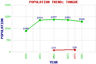
Tongue Classification and Statistics Settlement Type: village Population (1971): 129 (1961): 108 (1881): 1929(For parish) (1871): 2051(For parish) (1861): 2077(For parish) (1831): 2030(For parish) (1801): 1348(For parish) Tourist Rating: No Text of Entry Updated: 09-MAY-2019 Location Latitude: 58.4757°N Longitude: 4.4178°W National Grid Reference: NC 591 567 A range of modern and historical maps are accessible through the map tab on the right of this page Get directions by entering the UK postcode of your location, home or hotel here eg. EH1 3YT Use the tabs on the right of this page to see other parts of this entry Related Entries There are 46 related entries. (2 Attractions, 1 Council Area, 1 Historical County, 2 Families, 22 Features, 1 Parish, 0 People and 17 Settlements) Names that are not linked do not currently contain any information. Attractions: Dounreay North Coast 500 Council Area: Highland Families: Gordon MacKay Features: Beinn Stumanadh Ben Hiel Ben Klibreck Ben Loyal Ben Tongue Cnoc an Fhreiceadain Coire na Saighe Duibhe, Loch Coulside, Loch Craggie, Loch Dherue, Loch an Eriboll, Loch Kyle of Tongue Kyle of Tongue Causeway Loyal, Loch Melness, Strath Rabbit Islands Roan Island Slaim, Loch Sutherland Syre, Loch Tongue Bay Tongue House Historical Counties: Sutherland Parishes: Tongue Settlements: Achininver Altnaharra Coldbackie Forss Kirkiboll Lairg Lubinvullin Midtown Portvasgo Ribigill Scrabster Skerray Skinnet Skullomie Strathan Talmine West Strathan
There are 46 related entries. (2 Attractions, 1 Council Area, 1 Historical County, 2 Families, 22 Features, 1 Parish, 0 People and 17 Settlements)
Names that are not linked do not currently contain any information.
By using our site you agree to accept cookies, which help us serve you better