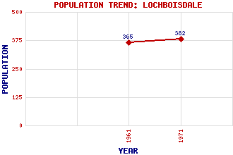
Lochboisdale (Loch Baghasdail) Classification and Statistics Settlement Type: village Population (1971): 382 (1961): 365 Tourist Rating: Text of Entry Updated: 29-APR-2016 Location Latitude: 57.1528°N Longitude: 7.3088°W National Grid Reference: NF 791 194 A range of modern and historical maps are accessible through the map tab on the right of this page Get directions by entering the UK postcode of your location, home or hotel here eg. EH1 3YT Use the tabs on the right of this page to see other parts of this entry Related Entries There are 48 related entries. (1 Attraction, 1 Council Area, 1 Historical County, 25 Features, 1 Parish, 0 People and 19 Settlements) Names that are not linked do not currently contain any information. Attractions: Ormiclate Castle Council Area: Western Isles Features: Ardvule, Rubha Barra Beinn Ruigh Choinnich Bhuailt, Rubha Boisdale, Loch Calternish Carrisaval Dunakillie, Loch Fada, Loch Gasay Iasgaich, Eileanan Kildonan, Glen Lochboisdale Harbour Melvick, Rubha Mor, Eilean Orosay Pabbay Roag, Loch Roneval Skiport, Loch South Uist Stulaval Stulaval, Loch Stuley Triuirebheinn Historical Counties: Inverness-shire Parishes: South Uist Settlements: Airdvuie Askernish Balla Daliburgh Drimsdale Garrynamonie Haun Howmore Laskir Ludac Mallaig North Lochboisdale Oban Pollachar Rubha Ban South Boisdale South Lochboisdale Stoneybridge Trossary
There are 48 related entries. (1 Attraction, 1 Council Area, 1 Historical County, 25 Features, 1 Parish, 0 People and 19 Settlements)
Names that are not linked do not currently contain any information.
By using our site you agree to accept cookies, which help us serve you better