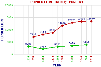
Carluke Classification and Statistics Settlement Type: small town Population (2011): 13579 (2001): 13454 (1991): 12921 (1981): 11676 (1971): 8864 (1961): 8110 (1951): 7126 (1881): 3792 (1871): 3423 (1861): 3111 (1841): 2090 (1831): 3288 Tourist Rating: No Text of Entry Updated: 07-JAN-2021 Location Latitude: 55.7323°N Longitude: 3.8376°W National Grid Reference: NS 847 503 A range of modern and historical maps are accessible through the map tab on the right of this page Get directions by entering the UK postcode of your location, home or hotel here eg. EH1 3YT Use the tabs on the right of this page to see other parts of this entry Related Entries There are 47 related entries. (2 Attractions, 1 Council Area, 1 Historical County, 8 Features, 17 Parishes, 7 People and 11 Settlements) Names that are not linked do not currently contain any information. Attractions: Bass Rock General Roy Birthplace Monument Council Area: South Lanarkshire Features: Carluke High School Carluke Railway Station Clyde, River Crawforddyke Garrion Burn Glasgow Central Railway Station Victoria Park School West Coast Main Line Historical Counties: Lanarkshire Parishes: Biggar Cambusnethan Carluke Carmichael Carnwath Carstairs Covington Dalserf Lanark Lesmahagow Libberton Pettinain Shotts Stonehouse Symington Walston Wiston and Roberton People: Robert Forrest Sir Angus Grossart John Gibson Lockhart William Thomson Neill Major General William Roy Sir Walter Scott Major Thomas Weir Settlements: Braidwood Crossford Glasgow Kilncadzow Lanark Law Roadmeetings Shieldmuir Waterloo Wildmanbridge Yieldshields
There are 47 related entries. (2 Attractions, 1 Council Area, 1 Historical County, 8 Features, 17 Parishes, 7 People and 11 Settlements)
Names that are not linked do not currently contain any information.
By using our site you agree to accept cookies, which help us serve you better