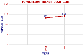
Lochaline (Loch Àlainn) Classification and Statistics Settlement Type: village Population (1971): 213 (1961): 200 Tourist Rating: N/A Text of Entry Updated: 19-JAN-2017 Location Latitude: 56.5377°N Longitude: 5.7766°W National Grid Reference: NM 679 448 A range of modern and historical maps are accessible through the map tab on the right of this page Get directions by entering the UK postcode of your location, home or hotel here eg. EH1 3YT Use the tabs on the right of this page to see other parts of this entry Related Entries There are 24 related entries. (1 Attraction, 1 Council Area, 1 Historical County, 15 Features, 1 Parish, 0 People and 5 Settlements) Names that are not linked do not currently contain any information. Attractions: Mull Council Area: Highland Features: Aline, Loch An Sleaghach Ardtornish Lighthouse Beinn Bhan Beinn Iadain Doire Daraich Fiunary Forest Glasa, Eileanan Glensanda Castle Glensanda Quarry Meall Damh Morvern Mull, Sound of Sidhean na Raplaich Tearnait, Loch Historical Counties: Argyllshire Parishes: Morvern Settlements: Acharn Achnaha Fishnish Larachbeg Tighachnoic
There are 24 related entries. (1 Attraction, 1 Council Area, 1 Historical County, 15 Features, 1 Parish, 0 People and 5 Settlements)
Names that are not linked do not currently contain any information.
By using our site you agree to accept cookies, which help us serve you better