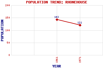
Rhonehouse (Kelton Hill) Classification and Statistics Settlement Type: hamlet Population (1971): 121 (1961): 143 Tourist Rating: N/A Text of Entry Updated: 25-OCT-2020 Location Latitude: 54.9164°N Longitude: 3.9639°W National Grid Reference: NX 742 597 A range of modern and historical maps are accessible through the map tab on the right of this page Get directions by entering the UK postcode of your location, home or hotel here eg. EH1 3YT Use the tabs on the right of this page to see other parts of this entry Related Entries There are 11 related entries. (1 Attraction, 1 Council Area, 1 Historical County, 1 Event, 4 Features, 1 Parish, 0 People and 2 Settlements) Names that are not linked do not currently contain any information. Attractions: Threave Gardens Council Area: Dumfries and Galloway Events: Leveller's Revolt Features: Birk Hill Brown Hill Dee, River Kelton Hill Historical Counties: Kirkcudbrightshire Parishes: Kelton Settlements: Castle Douglas Mid Kelton
There are 11 related entries. (1 Attraction, 1 Council Area, 1 Historical County, 1 Event, 4 Features, 1 Parish, 0 People and 2 Settlements)
Names that are not linked do not currently contain any information.
By using our site you agree to accept cookies, which help us serve you better