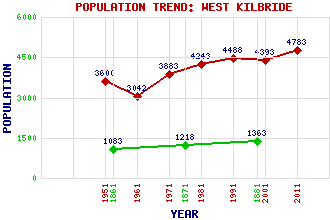
West Kilbride Classification and Statistics Settlement Type: village Population (2011): 4783 (2001): 4393 (1991): 4488 (1981): 4243 (1971): 3883 (1961): 3042 (1951): 3600 (1881): 1363 (1871): 1218 (1861): 1083 Tourist Rating: Text of Entry Updated: 19-JUL-2022 Location Latitude: 55.6914°N Longitude: 4.8493°W National Grid Reference: NS 210 479 A range of modern and historical maps are accessible through the map tab on the right of this page Get directions by entering the UK postcode of your location, home or hotel here eg. EH1 3YT Use the tabs on the right of this page to see other parts of this entry Related Entries There are 48 related entries. (4 Attractions, 1 Council Area, 1 Historical County, 27 Features, 1 Parish, 5 People and 9 Settlements) Names that are not linked do not currently contain any information. Attractions: Ayrshire Coastal Path Clyde Muirshiel Regional Park Hunterston 'B' Nuclear Power Station West Kilbride Museum Council Area: North Ayrshire Features: Ardneil Bay Ardrossan Wind Farm Auld Hill Blackshaw Hill Busbie Muir Reservoir Caaf Reservoir Caldron Hill Campbelton Hill Clyde, Firth of Cunninghame Gill Hill Glenburn Reservoir Goldenberry Hill Green Hill Hunterston 'A' Nuclear Power Station Hunterston Terminal Knockendon Reservoir Knockewart Hills Law Castle Law Hill Munnoch Reservoir North Hill Portencross Castle Tarbert Hill West Kilbride Golf Club, The West Kilbride Railway Station West Kilbride War Memorial Historical Counties: Ayrshire Parishes: West Kilbride People: James Andrew Anderson Nicola Benedetti Evelyn Hood Peter Angus Macnab Robert Simson Settlements: Ardrossan Blackshaw Farm Dalry Fairlie Goldenberry Munnoch Portencross Seamill Thirdpart
There are 48 related entries. (4 Attractions, 1 Council Area, 1 Historical County, 27 Features, 1 Parish, 5 People and 9 Settlements)
Names that are not linked do not currently contain any information.
By using our site you agree to accept cookies, which help us serve you better