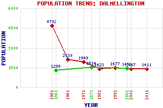
Dalmellington Classification and Statistics Settlement Type: village Population (2011): 1411 (Combined with Burnton) (2001): 1407 (1991): 1477 (1981): 1423 (1971): 1949 (1961): 2130 (1951): 4702 (1881): 1453 (1871): 1514 (1861): 1299 Tourist Rating: Text of Entry Updated: 31-AUG-2020 Location Latitude: 55.3227°N Longitude: 4.3955°W National Grid Reference: NS 481 058 A range of modern and historical maps are accessible through the map tab on the right of this page Get directions by entering the UK postcode of your location, home or hotel here eg. EH1 3YT Use the tabs on the right of this page to see other parts of this entry Related Entries There are 52 related entries. (5 Attractions, 1 Council Area, 1 Historical County, 32 Features, 1 Parish, 1 Person and 11 Settlements) Names that are not linked do not currently contain any information. Attractions: Dalmellington Moss Doon Valley Museum Dunaskin Open-Air Museum Loch Doon Castle Scottish Industrial Railway Centre Council Area: East Ayrshire Features: Auchenroy Hill Ballochling Loch Benbeoch Benbrack Benquhat Hill Birny Hill Bogton Loch Bradan, Loch Campbells Hill Carrick Forest Cornish Loch Coyle, Water of Craigengillan Dalnean Hill Doon Academy Doon Valley Doon, Loch Dunaskin Glen Enoch Hill Glasgow South Western Line Glenmuck Craig Goosie, Loch Laggeran Hill Linn Water Muck Water Muck, Glen Ness Glen Pickan's Dyke Railway Viaduct Riecawr, Loch Todden Hill Windy Standard Historical Counties: Ayrshire Parishes: Dalmellington People: Andrew Barclay Settlements: Ayr Bellsbank Burnton Carsphairn Drumjohn Gass Maneight Patna Pennyvenie Straiton Waterside
There are 52 related entries. (5 Attractions, 1 Council Area, 1 Historical County, 32 Features, 1 Parish, 1 Person and 11 Settlements)
Names that are not linked do not currently contain any information.
By using our site you agree to accept cookies, which help us serve you better