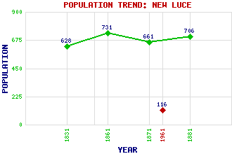
New Luce Classification and Statistics Settlement Type: village Population (1961): 116 (1881): 706 (1871): 661 (1861): 731 (1831): 628 Tourist Rating: N/A Text of Entry Updated: 27-MAR-2007 Location Latitude: 54.9425°N Longitude: 4.8522°W National Grid Reference: NX 174 646 A range of modern and historical maps are accessible through the map tab on the right of this page Get directions by entering the UK postcode of your location, home or hotel here eg. EH1 3YT Use the tabs on the right of this page to see other parts of this entry Related Entries There are 38 related entries. (2 Attractions, 1 Council Area, 1 Historical County, 28 Features, 1 Parish, 2 People and 3 Settlements) Names that are not linked do not currently contain any information. Attractions: Laggangairn Standing Stones Southern Upland Way Council Area: Dumfries and Galloway Features: Artfield Fell Wind Farm Balmurrie Fell Wind Farm Big Craigenlee Big Milldown Cairnerzean Fell Cairnscarrow Closs Hill Craig Fell Craigbirnoch Fell Cross Water of Luce Cruise Burn Cruise Fell Dirniemow Fell Drumminnoch Glaster, The Gleniron Fell Glenkitten Fell Green Top Horse Hill Kilhern Loch Knockniehourie Laganabeastie Hill Luce, Glen Luce, Water of Main Water of Luce Miltonish Mulniegarroch Pilgrim's Way, The Historical Counties: Wigtownshire Parishes: New Luce People: Saint Fillan(St. Fillan) Alexander Peden Settlements: Barr Glenluce Miltonise
There are 38 related entries. (2 Attractions, 1 Council Area, 1 Historical County, 28 Features, 1 Parish, 2 People and 3 Settlements)
Names that are not linked do not currently contain any information.
By using our site you agree to accept cookies, which help us serve you better