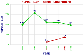
Carsphairn Classification and Statistics Settlement Type: village Population (1991): 180 (1961): 61 (1881): 484 (1871): 545 (1861): 553 (1841): 790 (1801): 496 Tourist Rating: Text of Entry Updated: 08-AUG-2009 Location Latitude: 55.2111°N Longitude: 4.2615°W National Grid Reference: NX 562 931 A range of modern and historical maps are accessible through the map tab on the right of this page Get directions by entering the UK postcode of your location, home or hotel here eg. EH1 3YT Use the tabs on the right of this page to see other parts of this entry Related Entries There are 52 related entries. (1 Attraction, 1 Council Area, 1 Historical County, 1 Family, 39 Features, 1 Parish, 1 Person and 7 Settlements) Names that are not linked do not currently contain any information. Attractions: Carsphairn Heritage Centre Council Area: Dumfries and Galloway Families: MacAdam Features: Alhang Alwhat Appin Burn Bardennoch Hill Beninner Benloch Burn Big Meaul Black Shoulder Bow Burn Brownhill Rig Cairnsmore of Carsphairn Carlin's Cairn Carsphairn Lane Coran of Portmark Cornharrow Hill Craig of Knockgray Craigdarroch Glen Craigengillan Hill Craigfionn Deugh, Water of Dodd Hill Dugland Dundeugh Hill Dunool Ewe Hill Glenkens, The Kendoon Loch Macaterick Marscalloch Hill Moorbrock Hill Nether Hill Slochy, Loch Upper Hill Wee Meaul Wether Hill Wether Hill Wind Farm White Hill Willieanna Windy Standard Wind Farm Historical Counties: Kirkcudbrightshire Parishes: Carsphairn People: Rodger Dunn Settlements: Craigengillan Dalmellington Drumjohn Dundeugh Knowehead Polmaddie Woodhead
There are 52 related entries. (1 Attraction, 1 Council Area, 1 Historical County, 1 Family, 39 Features, 1 Parish, 1 Person and 7 Settlements)
Names that are not linked do not currently contain any information.
By using our site you agree to accept cookies, which help us serve you better